Map Showing 3 PA
Regions
You are
here: Track2
RailNet Home Page>
Displays
> Map Showing 3 Pa Regions (B4.1)

Which Counties
Are In Each Of The 3 Regions
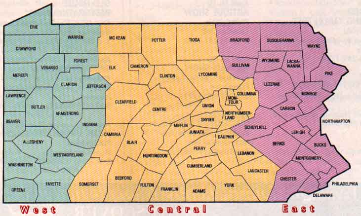
The above map shows how how the state
is divided into 3 Regions
by Pennsylvania
Magazine . The counties in each
region are as follows:
- West
Region -- 18 counties: 1)
Allegheny, 2) Armstrong, 3) Beaver, 4) Butler, 5) Clarion, 6)
Crawford, 7) Erie, 8) Fayette, 9) Forest, 10) Greene,, 11)
Indiana, 12) Jefferson, 13) Lawrence, 14) Mercer, 15) Venango, 16)
Warren, 17) Washington, 18) Westmoreland
- Central
Region -- 30 counties: 1) Adams, 2) Bedford, 3) Blair, 4) Cambria,
5) Cameron, 6) Centre, 7) Clearfield, 8) Clinton, 9) Columbia, 10)
Cumberland, 11) Dauphin, 12) Elk, 13) Franklin, 14) Fulton, 15)
Huntingdon, 16) Juniata, 17) Lancaster, 18) Lebanon, 19) Lycoming,
20) McKean, 21) Mifflin, 22) Montour, 23) Northumberland,, 24)
Perry, 25) Potter, 26) Snyder, 27) Somerset, 28) Tioga, 29) Union,
30) York
- East
Region -- 19 counties: 1) Berks, 2) Bradford, 3) Bucks, 4) Carbon,
5) Chester, 6) Delaware, 7) Lackawanna, 8) Lehigh, 9) Luzerne, 10)
Monroe, 11) Montgomery, 12) Northampton, 13) Philadelphia, 14)
Pike, 15) Schuylkill, 16) Sullivan, 17) Susquehanna, 18) Wayne,
19) Wyoming
This page modified 6/19/02

